Hurricane Erin Rapidly Intensifies to Category 5 in Historic Atlantic Surge
Hurricane Erin jumped from a Category 1 to a monstrous Category 5 in just over a day. That kind of rapid-fire growth is rare, and it has got meteorologists locked in.
As of now, Erin is spinning in the Atlantic, no longer at peak strength but still powerful. It is currently a Category 3, with winds around 125 mph. But don’t relax yet. These kinds of storms have a mind of their own, and Erin’s eye is going through a replacement cycle. That means it might wobble a bit in strength over the next few days.
On August 16, it was a standard Category 1 storm. By the next day, it had more than doubled in strength, peaking at 160 mph winds. That puts it among the fastest-growing hurricanes in Atlantic history.
This kind of explosive growth needs just the right ingredients. Warm ocean water, low wind shear, and a moist atmosphere all came together like rocket fuel.
Where is Erin Now?
Right now, Hurricane Erin is about 330 miles east-southeast of Grand Turk Island. It is cruising west-northwest at 14 mph. But early next week, it is expected to curve northward into the Atlantic.
The good news? Erin isn’t expected to hit land directly. It will pass north of Puerto Rico, the Virgin Islands, and the northern Leeward Islands. Still, it is close enough to stir things up.
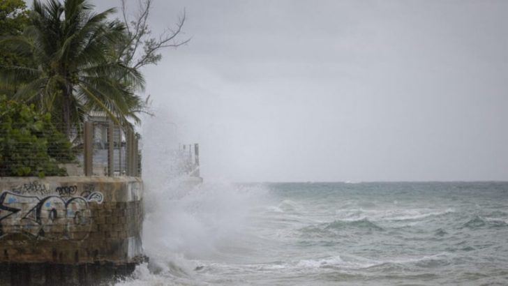
Craig / Unsplash / The Turks and Caicos and parts of the northern Leeward Islands are under tropical storm watches. That means gusty winds and heavy rain could still hit.
Rainfall between 2 to 6 inches could lead to flash floods, landslides, and mudslides, especially in Puerto Rico and nearby islands. The ground is already soaked in some places, and it won’t take much to trigger problems.
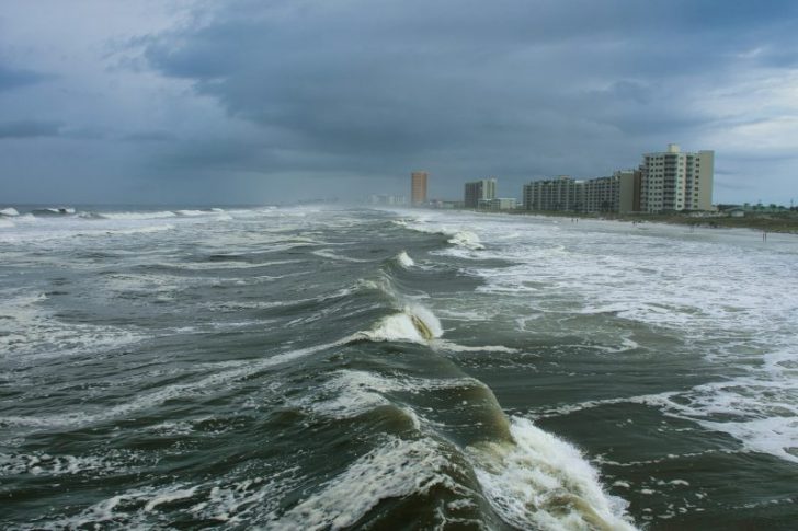
Dangerous Waves Incoming
One of Erin’s biggest threats isn’t even the wind or rain. It is the ocean. Life-threatening surf and rip currents are expected all along the U.S. East Coast, the Bahamas, and even parts of Atlantic Canada next week.
So, even if the storm stays offshore, it is still dangerous. Beaches that look calm could be hiding deadly rip currents. Local officials are urging swimmers and surfers to stay cautious.
Right now, forecast models show Erin curving away from the U.S. East Coast. Those “spaghetti plots” are mostly pointing north, into the open Atlantic. That is thanks to a high-pressure system and an incoming cold front, which are nudging Erin out to sea.
Hurricane Erin is part of a bigger story. It is the fourth year in a row with a Category 5 hurricane in the Atlantic. That is not random. Warmer ocean waters and rising global temperatures are giving these storms more fuel, earlier in the season.
GTN / Hurricane Erin shows how fast climate change can change things. What started as a mild tropical storm turned into a historic monster in just 24 hours.
That kind of speed challenges forecast systems and gives coastal communities less time to prepare.
Just because Erin is headed north doesn’t mean the danger is over. The Atlantic hurricane season runs through November, and this storm shows how quickly things can spin up.
Keep an eye on updates, especially if you are in the Caribbean, on the East Coast, or planning to be near the water. Storms like Hurricane Erin can change direction fast, and the impacts can stretch far beyond the center.